Saint Lawrence River Secrets app for iPhone and iPad
This manual was designed for the purpose of safety and training for all users of the St. Lawrence River. This river, the longest inland navigable waterway in the world, is fascinating in more than one point but can reserve several surprises for navigators eager to discover it.
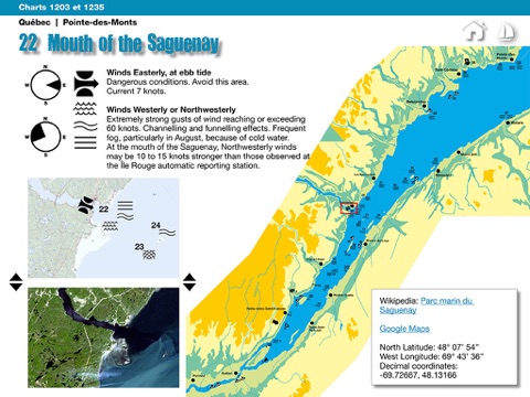
You will find a directory of 142 sites that can be dangerous when winds interfere with coastal topography. This inventory was conducted using information collected from river users such as fishermen, sailors and boaters not to mention the expertise of scientists and representatives of the Canadian Coast Guard.
This information is presented on simplified topographic charts over which are superimposed the data from the wind, waves, current and topography.
The listed effects in this manual are exactly those described in the Wizvox Media Marine Weather Guide such as:
• the effects of topography, on the direction and speed of winds
• the effects of wind, on wave height and the sea behavior
• the effects of shoals and currents on the behavior of waves.
This directory is complementary to essential guides for safe navigation:
• Sailing rules (various suppliers)
• Charts (Canadian Hydrographic Service)
• Tables of currents and tides (Fisheries and Oceans Canada)
Pssst ...! The assessments about the difficulties of navigation in this manual, refer to vessels under 14 meters.
Distances and depths are in nautical miles, in meters and fathoms in order to match with the types of measurements which appear on the Canadian Hydrographic Service Marine Charts.


